|
Friends of Marymoor Park |
|
King County Department of Natural Resources
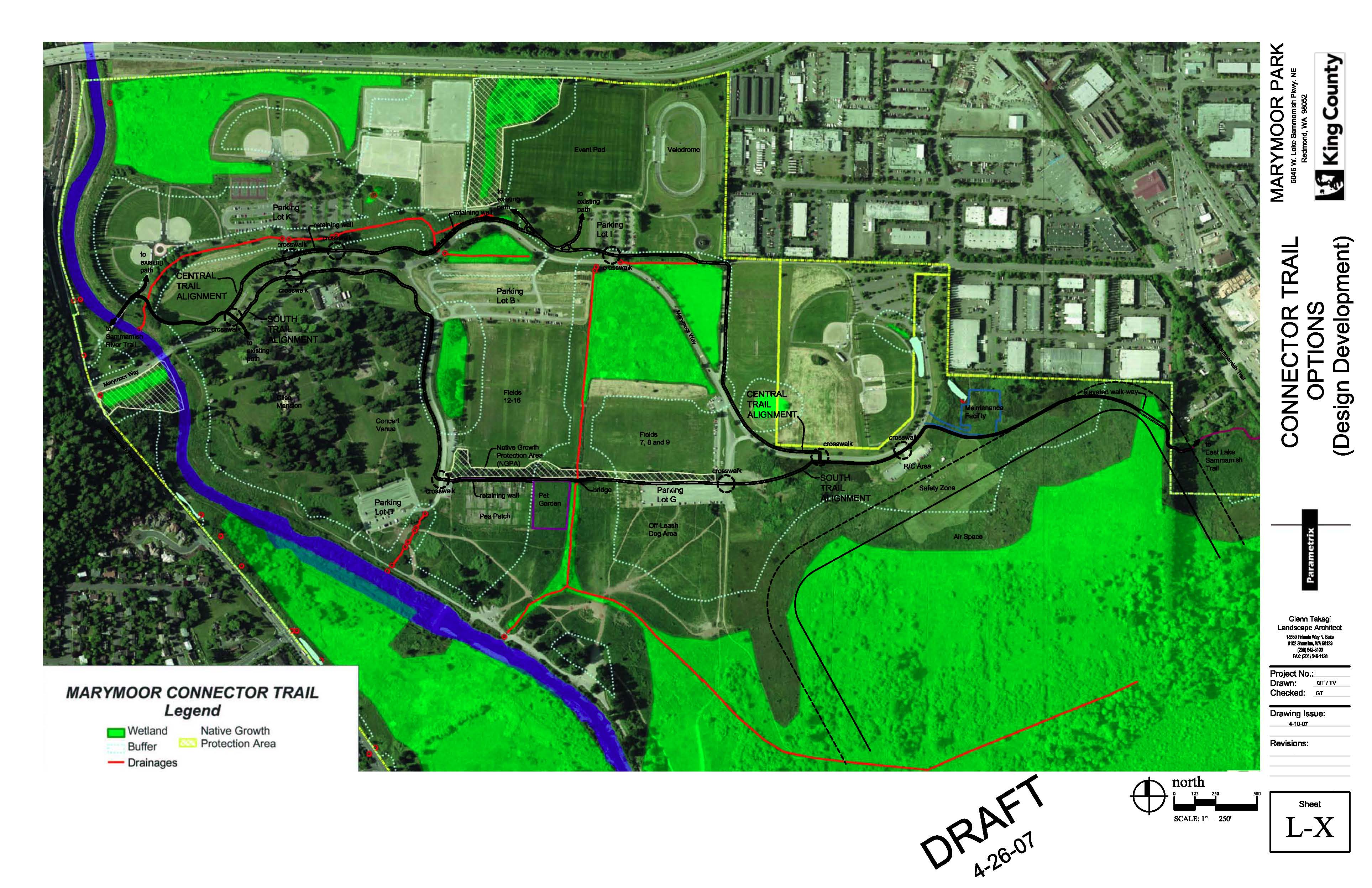
and Parks MARYMOOR CONNECTOR TRAIL - Public Meeting May 23rd. @ 7 p.m. @ Marymoor Park, Clise Mansion (Great Room) King County Parks is committed to provide a viable connection between the Sammamish River Trail and the East Lake Sammamish Trail. We are currently in the process of taking comments and input on two options for such a connection through Marymoor Park. These options have been developed taking in to consideration the Marymoor Park User Groups' needs as well as King County Park's objectives of providing a safer, more enjoyable regional trail experience for trail users of all ages and skills compared to the existing connections via surface streets, sidewalks, and paths. We are taking public input at the very early stages of the project so that any special needs or considerations are taken in to account while arriving at the final route through the Marymoor Park. A meeting has been scheduled on Wednesday, May 23rd, at 7 p.m. @ Marymoor Park, Clise Mansion, Great Room (address for Marymoor Park is: 6046 W Lake Sammamish Parkway NE Redmond, WA 98052). Parametrix Inc. and Glenn Takagi Assocs. ( Consultants for this project) will be presenting the two options for discussions and comments. The purpose of the trail is to provide a regional trail linkage between the Sammamish River Trail and East Lake Sammamish Trail. The two viable routes through Marymoor Park are based on the availability of the developable land, imposing relatively least permitting constraints associated with wetlands, streams and other native growth protection areas as well as creating least conflicts with the Parks' current and potential active/passive uses of Marymoor Park for various events and on-going activities. Cost, safety, maintenance, aesthetic appeal and an enjoyable experience for all users have been equally given consideration while coming up with the two options. For more information on the project you may contact K.K. Soi, Project Manger @ 206. 263.7283 or Norah Gaynor, Program Manager at Marymoor Park @ 206.296. 0673, Norah.Gaynor@metrokc.gov, or visit the King County Parks web site at www.metrokc.gov/parks/. MARYMOOR CONNECTOR TRAIL PURPOSE. The purpose of Marymoor Connector Trail is to provide a regional trail linkage between the Sammamish River Trail and East Lake Sammamish Trail. Currently, the southern terminus of the Sammamish River Trail is the west side of Marymoor Park, and the northern terminus of the East Lake Sammamish Interim Use Trail is in the vicinity of NE 70th Street, east of Marymoor Park. The proposed connector trail would offer a safer, more enjoyable option for trail users of all ages and skills than the existing connections via surface streets, sidewalks, and paths. CONSIDERATIONS. In trying to identify and evaluate possible routes through Marymoor Park, a number of criteria were considered. Potential alignments were mostly constrained by the availability of developable land—park areas not already in use for active or passive recreation and special events, and that are relatively unhindered by permitting constraints associated with wetlands, streams, and other native growth protection areas. Thus impacts on park programming and critical areas were two key criteria. Other considerations include cost, safety, aesthetic appeal, and connectivity. ALIGNMENT ALTERNATIVES. Initially, three alignments were identified through Marymoor Park: south, central, and north. However, the north alignment was eliminated due to permitting constraints and cost. The two remaining alternatives are described in more detail below and are depicted on the attached figure. The South Alignment exits the East Lake Sammamish Trail at the Hanson Property connection and extends west between the maintenance facility and the R/C area. The trail will be on a boardwalk or elevated structure where it crosses a portion of a large wetland. The alignment continues west along Marymoor Way and then leaves the roadway through Parking Lot G and along the south side of the native growth protection area (NGPA). The trail will cross the drainage between the off-leash area and the pet garden via bridge. It crosses Clise Way before turning north along the east side of the road. The alignment then parallels the south side of Marymoor Way before crossing the road and continues to the existing pedestrian crossing of the Sammamish River.
The location of the Central Alignment is the same as that of the South Alignment from East Lake Sammamish Trail through just west of the R/C area, where it crosses Marymoor Way. The trail route continues along the north side of the road before turning north towards the climbing rock (in order to skirt the triangular-shaped wetland area). The trail then turns westward and meets up with Marymoor Way. Once adjacent to Marymoor Way, the alignment essentially follows the road through the park. The alignment picks up the existing pedestrian crossing of the Sammamish River.
|
|
Home |
Mission | Members |
Events | News |
Maps | Getting There
| Contact Us | Links |
Search Problems, comments, suggestions? Email the FOMP webmaster at webmaster@marymoor.org |